

This was a big weekend for me in so many ways. My birthday was Sunday and we also selected a date for a cesarian as my daughter has decided she likes sitting upright in the breech position.
At 37 with a baby on the way, I really needed a big ride to remind myself why I love the long rides before I enter the unknowns of parenthood and long rides become a luxury. Youth's last stand.
For this day I chose to match the fearsome duo of distance and altitude for a blockbuster of a single-day ride.
I decided to ride from Taichung over Alishan's lesser used southern route (149甲), and then back to Taichung in a day.
The logistics of a ride like this are never easy. Several factors need to be taken into consideration including food, hydration, speed, endurance, emergency supplies, alternate routes, mechanical issues and a whole range of scenarios that can keep a rider up all night.
I had not done a significant ride in twenty days as I took a week off to recover and then got rained out. Carbo-loading for these rides can get expensive, so when they fail you are stuck paying for a meal larger and more expensive than you really needed.
I packed in pizza and pasta the night before, with a fruit smoothie before bed. I really couldn't afford to eat like that for another weekend without doing something with it.
The weather checked out for the day, so I packed my yellow distance backpack with:
- Arm/Leg Warmers
- Warm Base Layer
- Tubes x2
- Tire (700x25c) x1
- Asthma Inhaler
- Antihistamine x4
- Tylenol x4
- Mini Pump
- Gels 150cal (small)x3
- Gel 180cal (large) x2
- Apples x2
- Pizza slice x2
- Waterproof bag x1
- Toolkit x1
- Phone
- I.D. Card
- Money (NT 2300)
The chances of something going wrong in an area far from a bike shop warrants the extra weight penalty. You just never know.... Especially on a solo ride.

After feeling as ready as I was going to be, I dozed off Friday night around 9:30pm to get some rest before the big day... until... a well-wisher, who shall remain anonymous, woke me up with a text to my phone at 11:30pm. I never got back to sleep. I rolled around in bed running through all the "what if" scenarios, worrying about my knee and getting pissed off about work.
I finally gave up on sleep and got suited up for battle, adjusted my tire pressure for a day in the saddle, slathered on another layer of chamois cream, and slipped out the door around 3:00am.

In the cool night air I was feeling it. It was game on and I was passing quickly through the pothole-lined intersections of the Highway 3. In the early morning many intersections are marked with flashing yellow lights and I took full advantage to duck on through in the absence of the usual snarl.
After reaching Zhushan in an hour and a half, I stopped for coffee to give the sun a bit more time to come out before heading into the mountains.
I could see dawn was close as work gangs from the tea farms were gathering and milling about the 7-11 parking lot to hitch a ride up into the hills. They all wore rubber boots, hoods and had their fingers wrapped for protection.

I continued at a slower pace up the Route 149-A toward Caoling. I had ridden these roads before, so I could rate my progress and make adjustments in my level of effort. I was a little disappointed to be passing some spectacular scenery in the dark.

Any regrets over the scenery were soon put to rest at dawn, when I realized the entire area was covered in a haze from the moist air rising up out of the ground. It was one of those days that seemed to be perpetually morning. (For better pictures of this route see this earlier report)

The first climb was right where I'd left it, but this time I made real quick work of each hairpin and switchback.

I occasionally had to yield to large construction vehicles that were having a harder time than I was chipping into the mountain.

At several points the road folds back upon itself to reveal the river valley below with its speckles of rooftops and a built environment that is quickly dwarfed by the masses of nature.


By the time I crossed into Yunlin County I was feeling absolutely committed to finishing this ride.

I could look out in the distance at the rocky peak I needed to blast through before diving back down for the second ascent over Alishan. This was just the appetizer.

I edged up to the cliffside and could just make out the scarred roadways leading to the Caoling Tunnel. It just looked nasty. The whole hillside looked like it could lose grip on the bedrock entirely and slip off into the rubble pit below.
Everything in the village at the top told of a futile battle against the ravages of climate and weather. The construction from last year was the construction of this year. A fine, yellow dust was settled on just about every surface that hadn't crumbled into a showcase of roadside decay.


I finally found the even spot in the road and went for broke through the tunnel to Caoling.

Wham! The hilltops and manicured hostels are a welcome sight from the blight on just the other side of the ridge. It is like punching a hole into the center of the Central Mountain Range.

Yes, it is a pleasant sight for about five minutes until the moment of truth where you dive into Caoling and commit to finishing over Alishan. It was at this point I felt a little discomfort in my knee... the kind that has been dogging me for so many months. I kept stretching to push it out of my thoughts. Then I bombed into Caoling for a little breakfast of apples and gels.


Caoling is a little tourist haven tucked behind Alishan. There are waterfalls and hikes galore. I was able to swing by and replenish my water at one of the shops before sneaking out under the noses of a hundred gawking tourists.


Caoling's police station offers a bicycle rest station with a pump, restroom and supplies. Sadly, it is at the top of a long flight of stairs, so I gave it a miss at the risk of renal failure.

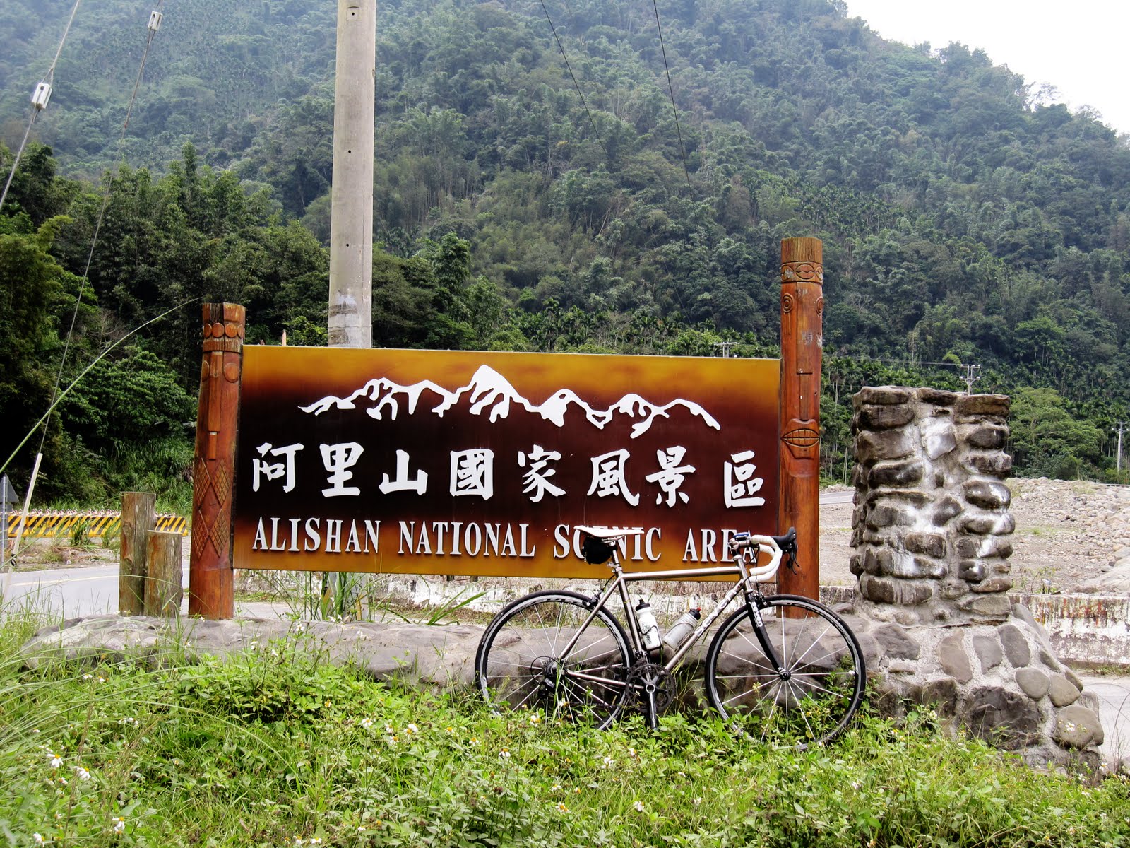
At the bottom of a screaming descent I found myself at the gates of Alishan National Scenic Area. There is just something incredible about crossing the threshold into one of Taiwan's great wilderness regions.


I ambled along the river past hostels and farms. The gravel business is booming along the Chingshui River. I was still waiting for a lick of sunshine that never arrived. Instead the clouds spit occasional droplets at be from behind foggy ridge lines.


At last I was on the 149甲 on my way up Alishan. The road work is never finished, and it will never finish in my lifetime, so I just took it as part of the experience. The bridge has been rebuilt, but there is always something to make things dirty.

I also never put on my daylight glasses. It just seemed too dark... all day.

I heaved and pressed my way up the squiggle to Taiho Village. Just past the scene pictured above, there is the Taiho Restaurant and Hostel where you can buy refreshments if you need a little more to finish the climb. This part is all torn up and requires walking the bike around the construction mess. After about 50m it is all clear to the top.
 From Taiho the rugged green tea farms open up and engulf the highest points of the mountain. Elephant Mountain sits off in the distance and plays on your imagination of exactly how rough Taiwan's wilderness can get.
There are still a few vestiges of Taiwan's Japanese colonial past when Alishan was both a logging, agricultural and tourist center. Push-car railways once meandered through these very mountains.


It was only 10:00am and I was closing quickly on the summit. I could easily map out my route as the white roadways slithered across the ripples below. Amazing!

My knee was far from happy, but still within finishing the ride. I was at 73 miles and I still had an entire trip back-- against the wind.


The drop into the tourist trap at Fenci Hu is quick, and the sight of shops, roast sausage and lovers looking lost on the roadside is actually quite warming after a long climb up the desolate back of Alishan.

I stopped for a coffee and a celebratory rest to eat my pizza. The fog was sticking to the mountains, so I didn't stay long. The last thing I needed was rain or any more cold.


A few other cyclists were making their way up the mountain from Chiayi. I passed a dozen or more on my way down the 159甲. I took few pictures on the way down as there was nothing to see in the haze and I just wanted to drop elevation and get on the road home.
What makes Alishan such a tricky mountain, is that it isn't what you'd normally expect. Usually an ascent is hard, but the descent is just the reverse. With Alishan, the descents all include a degree of climbing. This is especially rough if you've already humped up the thing... any incline is heartbreaking.
I bit down and made my final climbs on Alishan before screaming into Chiayi.
With nearly 100 miles under my belt for the day, I headed toward Taichung on the Highway 3.

The Highway 3 is pretty even around Taichung, but in the southern parts it undulates in a series of punchy climbs and steep dips.
For each climb I would leap out of the saddle and pull my ass to the top. My energy dipped a little, which was remedied with some sugar.
I finally made it to the area around Mingjian in Nantou County and made the fateful decision to follow the Changhua Route 137 home rather than simply going up the Highway 3 again. The difference was a trade of stop-and-go traffic for undulating hills and a little more distance with one final climb.
I just punched it up the 137 with some good speed and mighty bursts out of the saddle. I finally hit the Highway 74 and just ate it up. The adrenal gland is some powerful magic.
Then, just about 4km from home, all I could think about was chocolate. I couldn't ignore it. I stopped and downed a Kit Kat and a coke to fuel my push home. I had dropped 2-3mph from my usual sprint up the same road, but by the time I turned onto my street I was going full steam.
After a full day in the saddle, I was home for supper. My knee had remembered to get sore again and I was still feeling better than one might expect.
An awesome day of riding!
Score:
Distance: 250km/155mi
Altitude Gain: 3749m/12,303ft