body{background-attachment: fixed ! important; }
Showing posts with label Dong Shih. Show all posts

Thursday, February 5, 2015

Little Roads Make Big Rides: 東崎街,苗56, 花草坑農路, 130, 苗54-1, 苗49, 苗51-1

Untitled

A couple weeks ago I completed an absolute gem of a ride without going too far from home. For the majority of my ride I was alone with no other company other than the occasional eagle hovering above my shoulder or the garbled echo of a Taiwanese radio station being pumped into the orchards over a rusty sound system. 

Considering I was never really more than a dozen of so kilometers from busy towns and more densely populated cities, this type of cycling solitude is almost unheard of. 

It was only by stringing together a few country roads that I was able to put it all together into a single gleamingly clear day of riding. 

(I would love to provide a map, but it seems my mapping tool is experiencing some trouble.)

Untitled

The official beginning of this ride was in Dongshih, on the Dongqi St. (東崎街). 

Untitled

Dongqi St. is a shallow climb through the orchards on the ridge above Dongshih. It eventually tops off with a short climb before descending into the Da-an River. 

Untitled

I briefly linked to the riverside viaduct that leads back to Jhuolan where I caught up with the old Route 55 better known as Pinglin Rd. 

Untitled

Pinglin Rd. was quiet and delightful as usual. I did have to shoo off a couple of big dogs, but other than that it was its usual charming self. 

Untitled

After the first climb and descent on Pinglin Rd. near the Pinglin Elementary School, I made a left up the Hua-cao Keng Farm Rd. (花草坑農路). This is a tight climb along a forested hillside that is really a spectacle... until you get to the top of the hill where someone has used it as a garbage dump. 

Untitled

From the top I couple look out over the ridge to the larger hills looming on the horizon. 

Untitled

I made a link to the 54-1 that dipped into one of the more remote fingers of the Liyu Reservoir. 

Untitled

So much of the route was like this. A dip into a hidden gully or an arc along a a bare orchard. 

Untitled Untitled

I was eventually dumped off on the Highway 3, where I plodded up the asphalt onto the Route 130. 
Although I have climbed the 130 several times. I had never taken the 56 from the lower section of the 130. I had exited there before, but never the opposite way. Therefore, I was a bit surprised by the degree of climbing I had to commit to on the eastern end. 

Untitled

I chipped away at the hill and snap a picture or two as I emerged from the forest into sunlight. Then it was back into the forest for more climbing. 

The descent was a bit rough, but some parts smooth out for a good swooping drop. 

I hit the Route 49 and let gravity pull me to the base of my final climb up the 51-1 toward Sanyi. 

It is a bit of a chug to hack up that long climb into Sanyi. The gradient isn't too bad, but the hill is broad enough to make it a fair bit of work. 

Untitled

I continued along the 51-1 as afternoon sunshine filtered through the gaps in the canopy above. It was completely peaceful. What a wonderful road. 

Untitled

By the time I dropped out of the hills, I had been passed by no more that a dozen cars over the course of the ride. 

This is a route that will go on record as one of my all time favourites. 

This was 140km of riding from Taichung that well have been a million miles away. 

Untitled Untitled

Monday, October 1, 2012

Taking The Typhoon's Tail to Dongqi Rd.

IMG_9504

Saturday morning started off a little slower than normal. I had made up my mind to ride, but even as I rolled along Gongyi Rd. I still hadn't decided where I was going exactly. This is a bad. You should never set out for a ride without knowing what you would like to accomplish. This is the road to heartache.

The only thing I really wanted to accomplish was to get on my bike and ride it.

I finally settled on the foothills between Taichung and Jhuolan Township in Miaoli County.

IMG_9495

With a passing typhoon still lurking nearby, the winds were mixing it up every which way. The only real plan I had on the day was to go into the headwind on the way out and coast on a tailwind for the return. No more than three blocks from my door, I determined there was no possible way to tell which way the wind was blowing and so I figured the safe bet might be to head for the hills. At least with a hill you have the satisfaction of climbing something as opposed to just battling the wind to a draw between gusts.

As I lurched along, my face pummeled by a barrage of cold licks to the chops, I bore down on my crank to make it to the edge of town. My lips were already in a noticeable snarl. Funny how close the grimace of anger and pain looks to a full smile. I am sure I looked like the happiest cyclist in town.


IMG_9496

I figured a climb up to Hsinshe would be fun and steadily made my way over the top as I watched in half amusement as other riders gingerly negotiated the crosswinds on the way down.

IMG_9499

I took a coffee break in Dongshih. Alone on a windy day, my coffee break meandered from being a short rest, into a full vacation. It is too easy to enjoy a hot cup of coffee and watch life pass by a decorated window. Compared to the alternative of chopping my way through a thicket of crosswind, a 7-11 counter wasn't at all half bad.

IMG_9506

Eventually the fighting spirit returned and I threw myself into the hills on Dongqi Rd. behind Dongshih.  The Route 47 meanders through orchards and along deep gullies on a little used road to Da An River.

IMG_9508

Made pretty good time and started to lose myself in my thoughts and in my headphones.
The sudden and unexpected arrival of a city bus brought me back to the road.

IMG_9510


IMG_9515

Dongqi Rd. eventually empties out in on of the Atayal villages the Japanese used to keep a closer eye on the populace. The first mark that I had entered the village was a brand new rainbow gate. No, it is not an LGBT event. The rainbow symbolizes the Rainbow Bridge in Atayal folklore. Atayal tradition holds that when an Atayal dies, he must walk across the Rainbow Bridge to his ancestors. Of course, to show the utux, or spirit, that he has lived a fulfilling life as an Atayal man, he must raise his hand and it will be dyed black from the blood of those whose heads he has taken. A woman must also show her hand that has been blackened by the dyes of weaving. The old symbols have become a major tourist attraction in Taiwan.

IMG_9524 IMG_9528 IMG_9529

I finally spilled out into the riverbed and hammered for home with a healthy tailwind.

IMG_9531

The ride was only 100km, but it felt like 160km. Dongqi Rd. is still a wonderful ride despite the wind.

IMG_9538
WebRep
currentVote
noRating
noWeight

Sunday, July 29, 2012

Fighting Da Hsueh Shan: A Study in Taiwan Summer Cycling

IMG_8572
Regular readers may know that, for this rider, Da Hsueh Shan, the 28km of climbing out of the Dajia River Valley, is a mountain of disappointment. This is the climb that, on paper, shouldn't be anything extreme... and yet... every time I ride this mountain it seems things go smoothly. This is the climb where my other orange bike cracked the head tube. This it the climb where I ran out of gas while training for Wuling last year. This is the climb where I ran out of water on a surprisingly sweltering winter morning. This is the climb I have never felt I have made to feel "easy". 


After completing this ride I could only reflect upon how typical it was for a ride in the Taiwanese summer. The first thing to know is that the only predictable thing about a Taiwanese summer, is that Taiwanese summers are wildly unpredictable. 


I regularly get requests from riders thinking about visiting Taiwan and wondering if the weather will be suitable in the summer when most people have vacation. It is a hard question to answer as there are dry summers and wet summers. Summers are always hot and humid, but I find it completely manageable as long as I am moving and generating a little self-propelled A/C. 


Here is how this particular summer ride panned out. 


IMG_8535
I woke up early to get a jump on the day's extreme temperatures. In the humidity a slow climb can be simply torture in the direct sunlight. 


Summertime really doesn't give a rider much of a choice. You can either fight the climbs or fight the wind. Despite the boon of an eventual tailwind, the flats are a swirl of stiff crosswinds and the dreaded headwind from the south. I find winds to be more demoralizing than the hills because when you eventually get to the top of the hill you feel like you accomplished something. When fighting a wind, you just have a flat hill with no payoff. 


My legs creaked into service and I spent the entire way to Dongshih lamenting my inability to get the legs warmed up. 


As I started to get into rhythm around Dongshih, I turned up the road to Da Hsueh Shan... except it wasn't the road to Da Hsueh Shan. I swear the first few kilometers of Dong-qi Jie ( ) and Dong Keng Rd. look almost identical. It is easy to get sucked into the wrong task. Nothing against Dong-qi Jie, and I even contemplated just continuing to the DaAn River and up to the climbs above Tian Gou Village, but I really had a hankering to mount another campaign on Da Hsueh Shan. 


Of course, it was not lost on me that I had wasted a good chunk of morning coolness retracing my steps back to Dongshih, only to pedal four blocks over to the correct road. On the plus side, my legs were feeling better. 


IMG_8543
I kept a good speed on the lower parts of the climb, the sun was getting hot, so I tried to manage my water and keep moving. I wasn't sure how well I was climbing until I passed a group of three riders and they were gone as soon as they appeared. I knew the important parts of the climb, so I managed my energy accordingly with the right balance of soft pedaling and heavy pedal work on the ramps. 


I had stuffed a mini water bottle in my jersey pocket for use if the only water supply up on the mountain  had been closed. Luckily it was open of business and I stopped to refill. After standing in one place for a few minutes I looked down and noticed a growing puddle of perspiration fed by the natural conduits on my arms and legs. I couldn't tell if my stop was a good thing or if the heat was making it unbearable. 


IMG_8545
The morning traffic was picking up and the road was beginning to fill with caravans of luxury sedans and VW Transporter vans ferrying hikers up to the higher trails. 


IMG_8548
I threw myself onward and upward. Except for a section of harder climbing through the bamboo and cedar groves, most of the painful stuff was over. I was fairly pleased with my progress, but I felt I could have done a better job last year when I was in excellent climbing shape. 


One of the nice things about having a climb like this so close, is that in 10km you can go from thick, steamy jungle, to the cool shade of cedar boughs. It is an entirely different biome and reminds me of my time growing up in the Pacific Northwest of the United States. 


IMG_8556
Then, like as it always does, something happened on Da Hsueh Shan to bring my joyride to an end. 


First, I started to feel cramping in my right calf. It could have been the heat. It could have been the fact that the cleat was broken forcing me to ride different. It could have been that I needed to stretch a bit more. Or simply that I am not yet in shape to tackle this climb. But it happened. 


I kept playing with my position to ease the cramp away, but it kept pushing into my bones like a vise. As I tried to find a better angle to bring the cramping down, I guess I made the wrong move and triggered a severe cramp that locked my calf down tight. As I unclipped to straighten my leg out, my lower quad and hip seized up as well. This is not good at any time, but especially bad in the middle of a climb when there you can't seize the momentum to buy time to safely coast to a stop. 


I was a fraction of a fraction of a moment from tipping over onto my side, unable to unclip. Every rider with clip less pedals has had moments like these when you realize you need to unclip. The face is flushed with a wide-eyed expression of panic as the mind and body race for enough balance and poise to safely dismount. 


I straightened my leg out and spent some time to stretch under the shade of the forest. About the time the cicadas grew bold enough to start buzzing away I was back underway up to the 22km mark. My calf was still sore and threatening to flare up again. The goal was to punish my legs, so I was resolute in continuing to the end. 


Then, I noticed the blue sky and puffy clouds had been replaced with a matte grey blanket of cloud cover. It looked like rain, and the last place I wanted to be in the rain was up on a mountain. 


IMG_8576
Since something always happens to me on Da Hsueh Shan, I took the cramping and rain clouds as all the evidence I needed to turn tail and go for home. 


Welcome to the Taiwanese summer. It was still morning and I was already charging home in a mad dash to beat the rain. 


I took the descent pretty slow as the oncoming drivers were merciless in their occupation of the entire roadway. Several cars were ferrying bikes up the mountain. I have no clue where they ride when they get there. The road wasn't in really great shape anyways. There were pits, ruts and potholes dotting some of the best sections. I probably had my tires overinflated as well, leading to an amplification of each bump. I read the braille on the roadway with its message to take it a bit slower.


Once I reached Dongshih, I turned back to see the entire mountain had been consumed by an obvious rain cloud that was fast approaching. 


I realized I had to leave everything on the road before Taichung and turned as large a gear as I could manage in my race against a downpour. 


My quads burned white hot as I stayed on the big ring (53) for each climb on the way to and through Hsin She, continually downshifting to test the low end of my engine for enough grunt to outpace the winds. 


I also knew that I was in the red and there wasn't enough raisin bran in the system to keep it up. 


Sprinkles dotted my face and I contemplated calling it quits at a 7-11 where a nice cold ice cream might make the hurt go away, but Taichung looked clear so I kept the wheels on the road. 


I slid down the Route 129 to Dakeng and gave every last bit of energy pushing top speed to Beitun Rd. 


The legs were practically numb with exhaustion. I was done. Cooked. Finished. There was no more. My legs had been running on empty and every last bit of glycogen had been put to work getting me home. 


I ambled through the streets of Taichung no faster than a granny at the market. My legs were pulsating in oscillations between heat and soreness. 


I never did see the rain. It never arrived in Taichung and I have no clue if it drenched the hills over Dongshih or if it simply covered us with just enough spittle to inspire fear of a downpour. 


That is the game we play every summer. Can I bear the heat and get home with a decent ride in my pocket before the skies open up and force me to disassemble the bike to dry the bearings? 


I can't wait for Fall. 

IMG_8579

Monday, October 31, 2011

Hitting The Wall: Sima Xian Shan (150km)


Every committed cyclist knows the feeling. We've all been through periods where we can't-- for whatever reason-- ride when and how we would like to. Things come up, and October has been filled with too many surprises.

I find when I am not riding I start feeling... mean (in the Joe Greene kind of way). By mid-week I feel a pressure in my chest and a percolating anxiousness. Two weeks without a soaring plunge along some verdant mountain road or an elbow to elbow battle with a pack of scooters starts making me a little stir crazy. I had to put the rubber to the road.

Finally, I had a weekend with some real ride time scheduled.

Seeing as hills are typically the method of choice for the cycling flagellant, I picked one of the meanest local routes with the aim of suffering the fun back into my weekend.

I charted a course for the quad-ripping slopes of Sima Xian Shan.


It had been a while since I first rode this route, so I decided to do it with a little more panache and begin my ride in Dong Shih.

Although I rode from Taichung to Dong Shih, I really didn't consider the ride to have started until I was actually working my out from the Dong Shih Hakka Cultural Center near the bike trail.

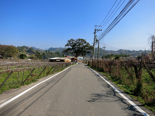
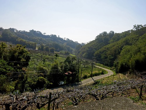
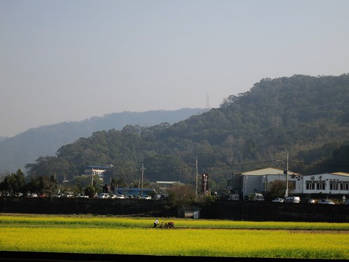
I was in less than ideal condition for a ride as ambitious as this one. I had not ridden a Century in a couple of months and I had spend the prior evening lurching in the zombified rigor mortis as one of the walking dead for Halloween. My back was sore from holding character and hobbling around on my feet for six hours in the perpetual state of dead. To make matters worse, my throat was dry and hoarse from all the hissing and growling required of any good zombie. Basically, I had not eaten enough, had enough fluids or rested properly for a nasty day of hills, but I was set in doing the ride after a couple friends stole my thunder by doing part of it the day before with a wonderful ride report full of all kinds of pretty pictures.


Dongqi Road is wends its way through Hakka style farms at treetop level above deep gullies and gurgling streams.


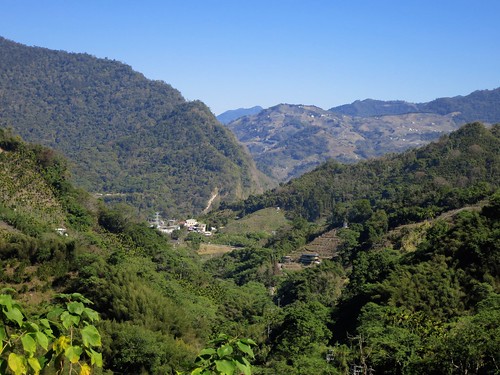
A wall of mountains sits beguilingly in the distance looking both massive and distant.


Despite the beauty and tranquility of this thin strip of tarmac, few cyclists actually take advantage of it, opting for the busier stretches of Guguan or Daxue Shan. Still, a couple riders were all smiles as they cut through the hills to Dong Shih.


As I steadily followed the sun drenched lines over the ridge to Jhuolan, I passed the ruins of the locally maligned BASF chemical facility. Local government had been bully on the unpopular project and hoped to steamroll local opposition to the facility. It appears local opposition may have won this battle as the nearly completed building rots by the roadway.


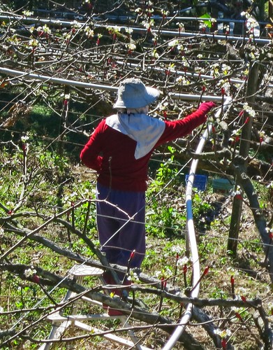
All along the route the hillsides were dotted with the popcorn white coverings of ripe persimmons. Aside from just being my favorite metaphor borrowed from pulp lesbian literature, I think they're pretty tasty as well.


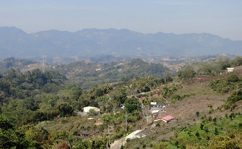
This route always surprises me with the number of creeks and streams that run "untamed" out of the mountains. It gives one hope that there are still hidden places in Taiwan that busloads of Chinese tourists will never discover.


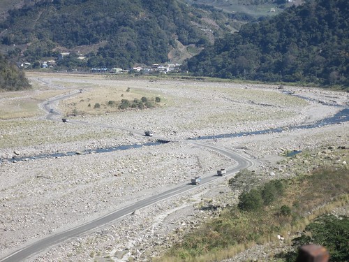
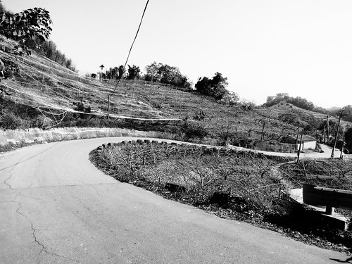
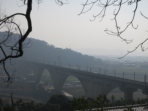
Dongqi Rd. drops down into the Da An River Valley and skims along the riverbank beneath hillside farms and towering cliffs.


Much of the road is smooth, but there are some rough patches that might require a little more care.


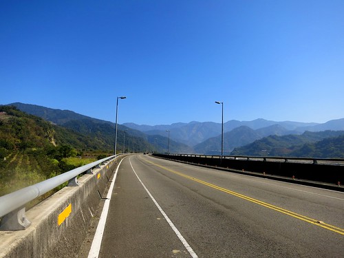
I passed several riders flying along in the opposite direction. Judging by the group and the terrain, I can only assume, at that time of day, they left the same way they came in. They seemed to be enjoying the deceptively easy rolling descent downriver.


I pushed along below the sheer canyon walls through several small agricultural villages, when I heard the F-ing sound of huge volumes of air exiting my rear tire. fffff-fffff-fffff-fffff, it gushed in looping rhythm to the rotation of my tire. I could feel the cool rush of air on my calves as the puncture passed between my stays.

I had experienced a flat Wednesday night and I noticed the hole was in the exact same location. This could only mean a rip in the tire. Sure enough, I found a hidden gash inside one of the treads where the high pressures pushed the tube through for a blow-out.


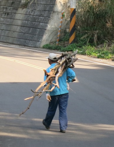
As I sat on the ground working on my tire, a local farmer came over to strike up a conversation. The only thing on his mind was talking politics.

The farmer was only two years older than myself and repeatedly mentioned how much he envied the USA for its ability to hunt down and catch or execute enemies of the state. He wished Taiwan could do the same to its enemies. He went on to tell me he hoped the pragmatic and moderate DPP candidate Tsai Ying-wen would get elected as she is "more level headed" than the more radical and activist policies of Ma Ying-jiu who, "...just wants to please Chinese and not Taiwanese." He also hoped Chinese would rise up and oust their leaders like the Arabs, so China could democratize and leave Taiwan alone.

Interesting opinions from a salt of the earth local living in the midst of a KMT voting district.


I cautiously continued on my way with 70psi in my rear tire. I hoped the pressure would be tight enough to get me through and weak enough not to push through the tire. All I could do was to avoid bumps and pits in the road. I still had another tube and if that went out then I'd be calling for a ride. I was still less than halfway through with a wall of climbing to conquer and a whole 90k back to Taichung along deserted mountain roads. With a plan like that how could I go wrong. I felt like I was rolling along mountain roads with a time bomb strapped to my wheel.


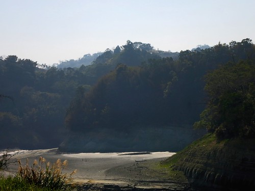
I finally pulled up to the reservoir, which marks the last rest stop before grappling my way up the mountain.


The reservoir near Xiangbi Village (Elephant Nose) is a scattering of produce farmers and tourists looking for a turn around. I saw several cyclists milling around taking in a little cigarette smoke to clear the lungs.


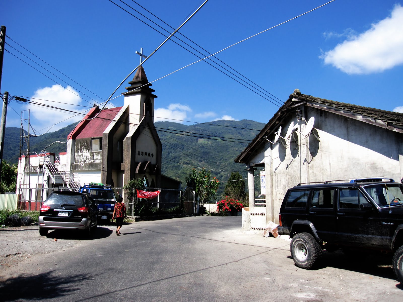
I breezed through the last villages near the riverbank, which consist mainly of a few Japanese era buildings, some shacks and platforms for locals to relax on, and tiny local churches for the predominantly Christian Atayal speaking population.


The river crossing is really the moment of truth. At the far end of the bridge lies one of the more heartbreaking sections of hill. The road suddenly vaults up with the first bend too far off in the distance to even register a simple "I think I can."


I dropped into my 39/12 gearing and torqued my way up like the chugging of a roller coaster as the chain drags the weight of the car up to the death drop.

Corner after corner, ramp after ramp I tried to keep my mind on the immediate challenges and try to convince myself the worst was over.

When I first climbed this hill it was hell. Somehow I had convinced myself it was not all that bad and easier than I thought. I was wrong on that count. It was still hell... and much worse. I was in and out of the saddle to even out the burn and rest the muscle groups.

I stopped in the Atayal village of Tiangou (Heaven Dog) to stock up on water and sport drink. The land they had cleared for tourism has been turned into farmland; a more practical use of local capital with better returns.

As I stood around hydrating and keeping the legs happy, I was soon surrounded by a number of local boys who forgot to inquire if I understood Chinese and started yammering away about the size of my dick and my sexy 70's chest hair and other stuff.

I finally tipped my hand and mumbled a term that indicated that the loudmouth of the bunch was pretty much full of shit. They quickly became a bit more respectful and started asking questions about my bike, my route and how on earth I ride without pedals.

Actually, I really liked the loudmouth kid. He had all the moxie and swagger you'd expect from a rock star.


I may have earned their respect when I took off and devoured the climb out of Tiangou with only a couple dozen or more easy, standing strokes. I could hear the hooting and cat calls from down below as the village disappeared behind me and I bit my lip into the next turn.


The climb kept throwing grades in my way and I tried my best to think happy thoughts.


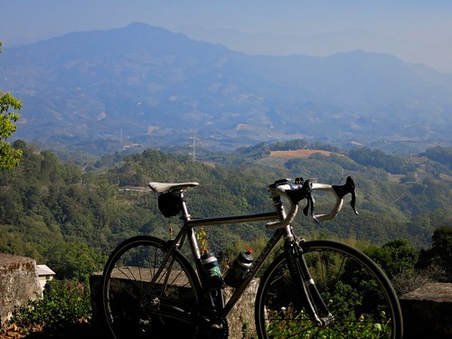
I lugged that bike higher over the valley floor as the view took some of the gravity off my shoulders. In the midst of such calculated suffering, there is also so much beauty. My inner quads in both legs started cramping, so I tried to play games and drink fluids to ease back into feeling normal.


As I neared the top I could see a plateau, which juts out over the river valley. It was here that the Japanese, in 1911, erected the Wan Tian gun battery following a number of disastrous engagements with the local Atayal, Hakka and Kaxabu speakers. After hundreds of troops drawn from Dong Shih, Jhuolan and Dahu were called up and failed, light aircraft were called up from Taichung to pummel the village into submission.

The people of Tiangou put up fierce resistance and eventually became a heavily policed village with the gun battery providing heavy support for tactical control the entire valley. The Japanese enlisted locals to engage in the camphor trade, timber and other forestry products. Several of the buildings still exist and a hike around the battery site makes for a wonderful adventure.


My time at the top was short lived. My flat had eaten up valuable time and I needed to beat it back home. Moreover, I felt my stomach growl.

There is a rule in cycling that you drink before you're thirsty and eat before you're hungry. I was still an hour of technical descending from Dahu and I feared a bonk was imminent.
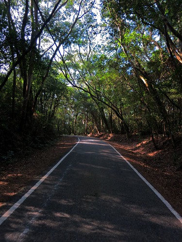
The forest roads on the back side of the mountain are shaded tunnels of bamboo and cedar. I tried to pick my lines and skate safely to the bottom. I didn't take many pictures of the descent, despite being on the more beautiful side of the mountain. All I could do was soak in the scene and avoid hitting anything that might cause a flat.


When in doubt, stay left. I was on a thrill ride to Dahu and all smiles. There is one ridiculously steep descent that slows things down, but what a marvelous drop. As I coasted along the green cliff sides, I surprised a gigantic eagle perched on a bald tree branch just off the road. My heart jumped when I caught the sudden movement of a large animal in my peripheral vision as it performed a plummeting swan dive into the void. Wow!


I was soon on my way out and into Dahu, where I immediately downed a coke and a couple of rice balls. With the wind at my back I cruised home at top speed eating the hills and surfing the descents.

This is why we suffer.


Totals:
Distance: 150km (93.94mi)
Altitude: 6178ft
Time: 6:33:39
Calories: 4657cal